
With this advisory, this blog's Ernesto watch ends.
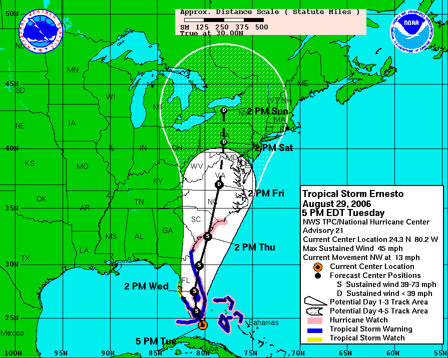
Tuesday, August 29
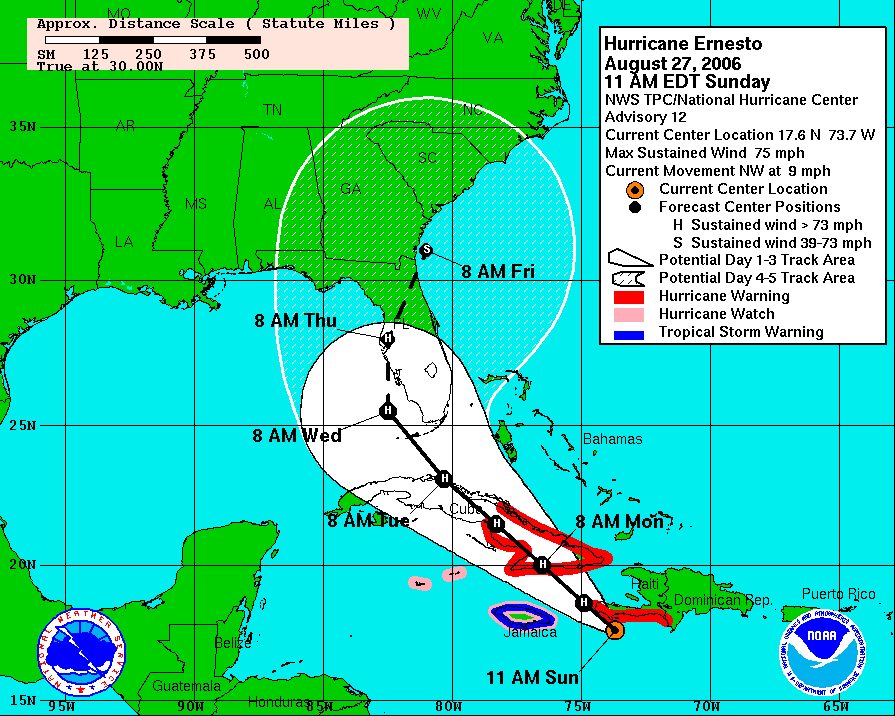
Sunday, August 27
Ernesto could be Category 3 at landfall
Here is the National Hurricane Center's 10 a.m. CDT discussion of Ernesto, which is now on a predicted path well out of the way of Louisiana.
Hurricane ERNESTO Forecast Discussion
HURRICANE ERNESTO DISCUSSION NUMBER 12
NWS TPC/NATIONAL HURRICANE CENTER MIAMI FL AL052006
1100 AM EDT SUN AUG 27 2006
ERNESTO'S CLOUD PATTERN IS STILL A BIT RAGGED-LOOKING BUT THERE ARE
SOME BANDING FEATURES OVER THE EASTERN SEMICIRCLE...AND CIRRUS
OUTFLOW IS EXPANDING OVER THE WESTERN PART OF THE CIRCULATION. THE
LAST AIRCRAFT-EXTRAPOLATED CENTRAL PRESSURE WAS 997 MB...SUGGESTING
THAT THERE HAS BEEN LITTLE OR NO STRENGTHENING OVER THE PAST
SEVERAL HOURS. WITH THE UPPER-LEVEL CYCLONE SHIFTING WESTWARD
TOWARD YUCATAN...THE SHEAR OVER ERNESTO IS QUICKLY DIMINISHING.
THUS THE PRIMARY CONSIDERATION IN THE INTENSITY FORECAST OVER THE
NEXT COUPLE OF DAYS WILL BE HOW MUCH THE TROPICAL CYCLONE INTERACTS
WITH LAND. ON THE CURRENT FORECAST TRACK...THE CENTER WOULD BE
OVER CUBA FROM HOUR 24 TO 48 HOURS. THIS SHOULD CAUSE SOME
WEAKENING AND THE OFFICIAL WIND SPEED FORECAST FOLLOWS THE DECAY
SHIPS MODEL RATHER CLOSELY. HOWEVER...AFTER THE CENTER MOVES INTO
THE SOUTHEASTERN GULF OF MEXICO...SIGNIFICANT RESTRENGTHENING IS
POSSIBLE. IT SHOULD BE NOTED THAT THE OFFICIAL FORECAST INTENSITY
AT 96 HOURS ASSUMES SOME WEAKENING DUE TO INTERACTION WITH LAND.
HOWEVER....ERNESTO COULD APPROACH CATEGORY 3 STATUS PRIOR TO THE
PROJECTED LANDFALL IN WESTERN FLORIDA.
INITIAL MOTION IS ESTIMATED AT 310/8. A CONTINUED NORTHWESTWARD
TRACK IS INDICATED BY MOST OF THE NUMERICAL GUIDANCE OVER THE NEXT
COUPLE OF DAYS. THIS WOULD TAKE ERNESTO OVER A SIGNIFICANT PORTION
OF CUBA. A MID-TROPOSPHERIC ANTICYCLONE OVER THE SOUTHEASTERN
UNITED STATES IS EXPECTED TO SHIFT EASTWARD AS A SHORTWAVE TROUGH
DROPS INTO THE LOWER MISSISSIPPI IN 3-5 DAYS. THIS SHOULD CAUSE A
MORE NORTHWARD HEADING LATER IN THE FORECAST PERIOD. THE 0600 UTC
RUNS OF THE GFS HAS SHIFTED A LITTLE TO THE WEST OF THE PREVIOUS
RUN BUT THE 0600 UTC NOGAPS HAS SHIFTED TO THE EAST. THE OFFICIAL
FORECAST TRACK IS NUDGED SLIGHTLY MORE TO THE RIGHT TO BE CLOSER TO
THE MODEL CONSENSUS. THIS IS EAST OF THE LATEST GFDL MODEL TRACK.
A TROPICAL STORM OR HURRICANE WATCH MAY BE REQUIRED FOR THE FLORIDA
KEYS AS EARLY AS 2100 UTC TODAY.
FORECAST POSITIONS AND MAX WINDS
INITIAL 27/1500Z 17.6N 73.7W 65 KT
12HR VT 28/0000Z 18.6N 74.9W 75 KT
24HR VT 28/1200Z 20.0N 76.5W 85 KT...INLAND
36HR VT 29/0000Z 21.5N 78.3W 75 KT...INLAND
48HR VT 29/1200Z 23.1N 80.3W 65 KT...INLAND
72HR VT 30/1200Z 25.5N 82.5W 85 KT
96HR VT 31/1200Z 28.0N 82.5W 80 KT...INLAND
120HR VT 01/1200Z 31.0N 81.0W 60 KT
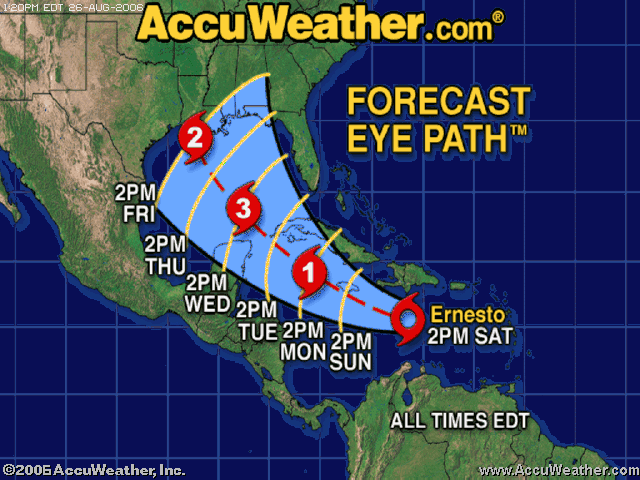
Saturday, August 26
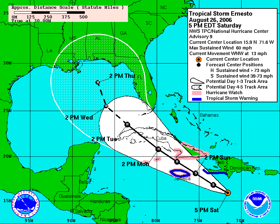
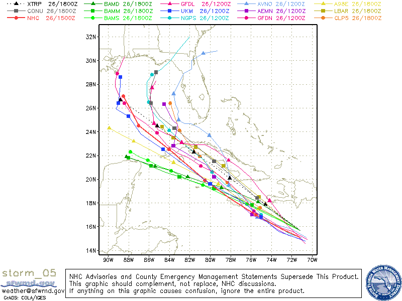
Projections have Ernesto heading for La.
We're watching the developments of Tropical Storm Ernesto around the clock.
Though projected paths are very tentative, as of this posting:
--The National Hurricane Center's projected path has Ernesto nearing the southeast Louisiana coast on Friday. Southwest Louisiana is within in the projected path's cone.
-- AccuWeather, whose forecasts appear daily in the American Press, projects a path in which Ernesto would strengthen in the open gulf into a Category 3 hurricane, lessen to a Category 2 and then strike the Cameron/Vermilion coastline Friday afternoon.
Projected paths are not definitive. Storms can and do change strength and direction for a variety of reasons.
Watching developments is the key. To help you, check back here often -- and visit the main newspaper Web site, www.americanpress.com, where you can access a hurricane tracking chart or download our entire 2006 Hurricane Season Guide, which has emergency information and preparedness tips.
BRETT DOWNER
Editor

Landrieu visits Cameron

On a tour timed to mark the one-year anniversary of Louisiana’s 2005 hurricanes, U.S. Sen. Mary L. Landrieu visited Cameron on Friday. Landrieu visited South Cameron High School, an LNG construction site and the Cameron docks. Landrieu’s Hope and Recovery Tour will conclude Sept. 23-24 with a series of events, including a coastal issues summit, in Southwest Louisiana.
Brad Puckett
American Press
Get AccuWeather updates via americanpress.com
News about Ernesto is available around the clock from the American Press' online AccuWeather weather center. Here's the address: http://hurricane.accuweather.com/hurricane/storms.asp?partner=apress&ocean=atlantic&storm=Ernesto&imagetype=move
Local government offices watch Ernesto
Tropical Storm Ernesto, which formed Friday over the Caribbean, could enter the Gulf of Mexico as a hurricane by mid-week.
The storm, on track to affect Jamaica by Sunday, has the eye of emergency officials in Southwest Louisiana.
‘‘There are many variables affecting the intensity and track that will develop and become more refined with time,’’ said Steve Rinard with the National Weather Service in Lake Charles. ‘‘While it is too early to overreact, the threat is present and should be ingested into your planning. Continue to monitor Ernesto through the weekend.’’
Norman Bourdeau of the Calcasieu Parish Office of Emergency Preparedness said the office will hold a briefing Sunday night to discuss the latest on the storm.
“If it becomes a hurricane by Sunday, we are going to meet. We are already making some arrangements here and making sure everything is ready to go,” he said.
“We are being watchful and taking care of the little things right now.”
Should Ernesto develop into a hurricane, it would be the first of the 2006 Atlantic season, the U.S. National Hurricane Center said.
Hector San Miguel
City Editor
Ernesto brewing; bound for Gulf?
The American Press Storm Blog is now watching the developments of Tropical Storm Ernesto.
Here is the text of a National Hurricane Center statement:
=================================================
Tropical Storm ERNESTO Forecast/Advisory Number 6
Issued at 0300 UTC SAT AUG 26 2006
AT 11 PM AST...0300Z...THE TROPICAL STORM WATCH HAS BEEN UPGRADED TO
A TROPICAL STORM WARNING ALONG THE SOUTHWESTERN PENINSULA OF HAITI.
A TROPICAL STORM WARNING IS NOW IN EFFECT FROM THE HAITI-DOMINICAN
REPUBLIC BORDER WESTWARD TO THE SOUTHWESTERN TIP OF HAITI.
A TROPICAL STORM WATCH REMAINS IN EFFECT FOR JAMAICA.
INTERESTS IN THE CAYMAN ISLANDS AND WESTERN CUBA SHOULD MONITOR THE
PROGRESS OF ERNESTO.
TROPICAL STORM CENTER LOCATED NEAR 14.8N 69.1W AT 26/0300Z
POSITION ACCURATE WITHIN 30 NM
PRESENT MOVEMENT TOWARD THE WEST-NORTHWEST OR 285 DEGREES AT 14 KT
ESTIMATED MINIMUM CENTRAL PRESSURE 1003 MB
MAX SUSTAINED WINDS 40 KT WITH GUSTS TO 50 KT.
34 KT....... 80NE 0SE 0SW 0NW.
12 FT SEAS..120NE 120SE 0SW 0NW.
WINDS AND SEAS VARY GREATLY IN EACH QUADRANT. RADII IN NAUTICAL
MILES ARE THE LARGEST RADII EXPECTED ANYWHERE IN THAT QUADRANT.
REPEAT...CENTER LOCATED NEAR 14.8N 69.1W AT 26/0300Z
AT 26/0000Z CENTER WAS LOCATED NEAR 14.5N 68.4W
FORECAST VALID 26/1200Z 15.6N 71.1W
MAX WIND 45 KT...GUSTS 55 KT.
34 KT... 80NE 40SE 0SW 40NW.
FORECAST VALID 27/0000Z 16.6N 73.7W
MAX WIND 50 KT...GUSTS 60 KT.
50 KT... 30NE 0SE 0SW 30NW.
34 KT... 90NE 90SE 60SW 90NW.
FORECAST VALID 27/1200Z 17.8N 76.4W...NEAR JAMAICA
MAX WIND 55 KT...GUSTS 65 KT.
50 KT... 30NE 0SE 0SW 30NW.
34 KT... 90NE 90SE 60SW 90NW.
FORECAST VALID 28/0000Z 19.0N 79.0W
MAX WIND 60 KT...GUSTS 75 KT.
50 KT... 30NE 0SE 0SW 30NW.
34 KT... 90NE 90SE 60SW 90NW.
FORECAST VALID 29/0000Z 22.0N 84.0W
MAX WIND 70 KT...GUSTS 85 KT.
50 KT... 50NE 30SE 30SW 50NW.
34 KT...100NE 100SE 100SW 100NW.
EXTENDED OUTLOOK. NOTE...ERRORS FOR TRACK HAVE AVERAGED NEAR 225 NM
ON DAY 4 AND 300 NM ON DAY 5...AND FOR INTENSITY NEAR 20 KT EACH DAY
OUTLOOK VALID 30/0000Z 24.0N 87.0W
MAX WIND 80 KT...GUSTS 100 KT.
OUTLOOK VALID 31/0000Z 26.0N 90.0W
MAX WIND 85 KT...GUSTS 105 KT.
REQUEST FOR 3 HOURLY SHIP REPORTS WITHIN 300 MILES OF 14.8N 69.1W
NEXT ADVISORY AT 26/0900Z
$$
FORECASTER MAINELLI/KNABB
Saturday, August 5
Chris fizzles out; season still quiet
Tropical Storm Chris appears to present no threat. The blog watch is off.
Brett Downer
Editor
Thursday, August 3
Now, all eyes turn to Tropical Storm Chris
We're watching the faraway developments of Tropical Storm Chris, which is currently about 125 miles northeast of Puerto Rico.
Current forecasts have the storm strengthening into a hurricane as early as this evening.
Its projected path, as plotted by the National Hurricane Center in Miami, puts Chris in the western Gulf of Mexico next Wednesday.
In conjunction with these developments:
--This blog now expands from Rita-related content to new, ongoing coverage of the current developments during this hurricane season.
--Our main newspaper Web site, www.americanpress.com, has just unveiled its redesigned, easier-to-navigate layout and new features. From the home page, you can access a hurricane tracking chart or download our entire Hurricane Season 2006 special section, which has emergency information and preparedness tips.
BRETT DOWNER
Editor
Wednesday, August 2
Cameron evacuee dies in FEMA trailer fire
By NAOMI GUIDRY
AMERICAN PRESS
CARLYSS — A fire engulfed a FEMA trailer early this morning, claiming the life of a Cameron Parish evacuee who lost her brick home during Hurricane Rita.
The victim had previously gone to the news media with concerns about the trailer’s safety. The fire’s cause is unknown.
Zeb Johnson of the Calcasieu Parish Coroner’s Office identified the victim as Ellen Schools, 51.
Carlyss Fire Chief Jude Savoie said firefighters were called to the scene at 2:13 a.m. The FEMA trailer is on a lot in the Hidden Ponds mobile-home park on Ravia Road south of Sulphur.
The fire was “heavily involved” when firefighters arrived, the chief said.
Schools had been living in the FEMA trailer since April, according to Jimmy LeJeune, who lives across the street.
LeJeune’s daughter-in-law, Paula LeJeune, said Schools had just started a new job. Her first day was Tuesday.
Jimmy LeJeune said he last talked to Schools at 11 p.m. Tuesday, when he called to tell her good night. Early Wednesday morning, he looked outside after hearing a noise and realized her mobile home was on fire.
“Flames were coming out of her living room,” Paula LeJeune said. “My husband tried to go in and get her, but the cop wouldn’t let him.”
At that time, a Calcasieu Parish sheriff’s deputy was at the scene.
“The cop knocked on the outside of the trailer and we heard a thud back,” LeJeune said.
Another neighbor, Mike Ravia, was alerted to the fire by a California man who had been staying in the RV park to the west.
“He was banging on doors to get everyone out. He couldn’t call 911 because his cell phone would have called 911 in California,” Ravia said.
The fire’s heat melted siding on his mobile home. He said he wanted to try to rescue Schools, but the roof over the kitchen/living area collapsed and the fire spread.
Schools had expressed problems with the FEMA trailer in the past. In May, she spoke to Theresa Schmidt, a reporter for KPLC-TV, about exposure to formaldehyde in the two-bedroom mobile home. She said the exposure was causing headaches, a sore throat and sinus problems.
According to the KPLC report, Schools said FEMA suggested that she open her windows to alleviate the problem.
Jimmy LeJeune said Schools had other problems with the trailer. He said the circuit breakers kept switching off and that he once witnessed smoke coming from the stove.
A FEMA official had no comment about whether Schools had reported problems in the past. He did say, however, that a FEMA safety group is investigating the fire.
The state fire marshal’s office is also investigating. Spokesman Marc Reech said investigators have not yet determined the cause or origin of the fire.
Weather Service watching new tropical storm
Roger Erickson, warning coordination meteorologist at the National Weather Service, has just issued the following:
>The National Weather Service is continuing to monitor the progress of Tropical Storm Chris. Chris is expected to become a hurricane either today or tomorrow.
>If Chris remains over open water between the Bahamas and Cuba, it could maintain its strength, but if it turns far enough to the left, and hits Cuba, Chris could weaken later this week or weekend.
>Right now, we believe Chris will be entering the southern Gulf of Mexico either late Sunday or Monday.
>By Wednesday, it is forecast to be in the central Gulf of Mexico. If high pressure remains strong over the northern Gulf, it will help steer Chris westward across the Gulf, but if the high weakens next week, Chris could turn more towards the northern Gulf.
>It's still too early to say what impact we will have locally, but we all need to keep an eye on this system.
Subscribe to:
Posts (Atom)
